Page 1 of 6
Fourth Age Maps
Posted: Wed Jul 29, 2015 10:21 pm
by michael.harrel
Hello All,
I'm running a game of TOR set in the fourth age, and am working on some maps for it. I'd love any and all feedback on them. (Links to larger versions below.)

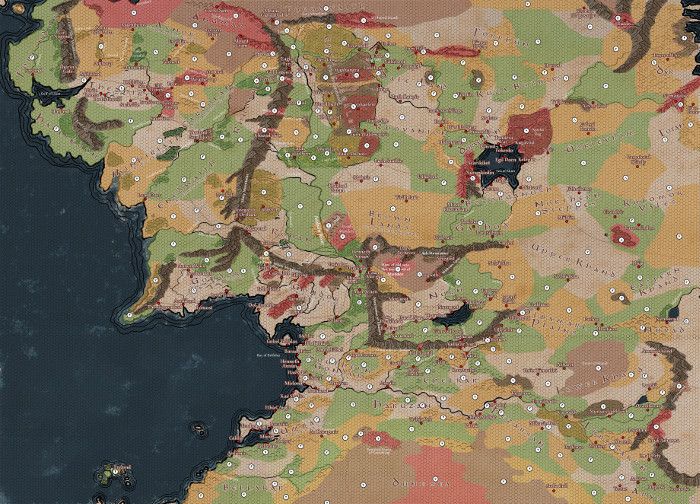
Full-size Versions:
Adventurer's Map
Loremaster's Map
GIMP file
GIMP Style guide (txt)
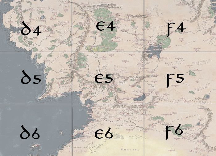
I'm also including the links to the sectional maps:
Re: Fourth Age Maps
Posted: Thu Jul 30, 2015 3:59 am
by Glorelendil
Beautiful work!
What is Tharbad Baran?
Re: Fourth Age Maps
Posted: Thu Jul 30, 2015 7:00 am
by Falenthal
The art is beautiful, very professional.
In my opinion, the Paths of Erech and the inside of Mordor should still be places touched by evil.
Also, I'd probably not make Fangorn and the Drúadan Forest as dangerous as the ruins of Barad-dûr. A yellow terrain would be enough.
Re: Fourth Age Maps
Posted: Thu Jul 30, 2015 10:47 am
by poosticks7
Looks good. I agree about dropping the terrain level on the two forests.
Also you forgot the town of Linhir in Gondor.
Re: Fourth Age Maps
Posted: Thu Jul 30, 2015 1:40 pm
by michael.harrel
Thanks for the input, everyone!
I've updated the maps a bit as per your comments, making most of Mordor still under shadow (while leaving the Men of Nurn an easier path along the Western edge, as they're a playable culture). I've added Linhir and adjusted some of the other terrain as well.
Adventurer's Map:
http://i68.photobucket.com/albums/i6/vi ... aicnb9.jpg
Loremaster's Map:
http://i68.photobucket.com/albums/i6/vi ... yzsvq0.png
Tharbad Baran (the "Brown Crossroads"(?)) are an invention of my own; I envision them as a small outpost of the Reunited Kingdom on the road to Eryn Lasgalen. Likewise Minas Rhovanion overlooks the eastern borderlands of the kingdom against raiders from Rhûn. The other stuff is at least attested in some work or another - Barad Nurn is from the recent Shadow of Mordor game, for example. In my game, the Dwarves of Aglarond have been engaged to turn the Paths of Erech into a passable way from Rohan to Gondor, which was the original reason they were easy terrain, but it's true that they're not so far into the project and maybe a little more difficulty is warranted.
Going forward, I think at least the Loremaster's map could use a few more ruins and other locations, such as Nargroth and the Seat of Seeing on Amon Hen, perhaps.
Re: Fourth Age Maps
Posted: Thu Jul 30, 2015 2:56 pm
by Glorelendil
michael.harrel wrote:In my game, the Dwarves of Aglarond have been engaged to turn the Paths of Erech into a passable way from Rohan to Gondor, which was the original reason they were easy terrain, but it's true that they're not so far into the project and maybe a little more difficulty is warranted.
Some great adventure possibilities in there before gentrification is complete.
Re: Fourth Age Maps
Posted: Mon Aug 03, 2015 9:58 am
by Robin Smallburrow
This is great Michael!
May I ask if you are aware of the Fourth Age stuff myself and Tolwen did in a previous issue of Other Minds? You can access my terrible map attempt in the link in my sig! I ask this because both myself and Tolwen did a Fourth Age Chronology for the Other MInds issue (I think it was Issue #9)
My own version of the Fourth Age had Minas Tirith renamed Minas Mallor, and the city in the Emyn Arnen was actually called Ost-in-Ernil. I had a town spring up called Sarn Ford at the borders of the Shire, to handle the growth of trade there. Isengard became isolated in a large forest, a tower for the learning of magic. A town flourished near Aglarond to handle the growth of trade to the dwarves. Fimbar was the name of the elven kingdom founded by Legolas in Nth.Ithilien.
Gorgoroth & the ruins of Barad-dur were shunned and desolate, although Elessar did rebuild or build more guard fortresses around it, the people of Nurn became a new independent kingdom.
This is just a brief summary of what I compiled, have lots more if you wish me to PM it to you!
Robin S.
Re: Fourth Age Maps
Posted: Mon Aug 03, 2015 4:22 pm
by Otaku-sempai
Interesting. Are you familiar with the Fourth Age map drawn by Karen Wynn Fonstad for
The Atlas of Middle-earth?
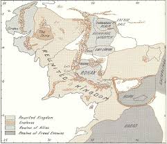
Click here for a larger image:
http://www.tolkienforums.com/Maps/map%2 ... %20Age.jpg.
My only issue with Tharbad Baran is that it might be easily confused with the Tharbad in Eriador which I suspect was restored in the Fourth Age to facilitate trade and travel between the Reunited Kingdoms.
Re: Fourth Age Maps
Posted: Mon Aug 03, 2015 5:27 pm
by michael.harrel
Robin Smallburrow: I've just sent you a PM

Otaku-sempai: Yes, I love that map from the Middle-earth atlas.
If Tharbad in Eriador does get rebuilt, I may give it a slightly different name, or a second word after Tharbad. So it would be a similar relationship as with Minas Tirith / Minas Morgul or Emyn Muil / Emyn Arnen.
Re: Fourth Age Maps
Posted: Tue Aug 04, 2015 3:10 pm
by Otaku-sempai
Robin Smallburrow wrote:My own version of the Fourth Age had Minas Tirith renamed Minas Mallor, and the city in the Emyn Arnen was actually called Ost-in-Ernil.
Robin S.
Re-naming Minas Tirith is a bold decision, Robin. Especially since Minas Tirith remains one of the two capitols of the Reunited Kingdoms in the Fourth Age. What prompted your change? And why Minas Mallor, rather than reverting to the city's original name of Minas Anor?