Page 1 of 1
Poll: Additional rivers of Rhûn
Posted: Tue Nov 10, 2015 3:31 pm
by michael.harrel
I'm starting to integrate Rhûn and the lands of the Easterlings into my Fourth Age map, but running into a bit of a quandary involving the difference between the maps from "official" canon and the MERP/Post-MERP fanon. It's a unique issue caused by interstitial position of the area: a little further East and we'll be out of canon entirely; a little further West and we're firmly in well-trod lands. The issue especially concerns a few extra rivers in MERP/fanon that flow into the sea of Rhûn. Here are a few images for comparison:
"Canon" Maps
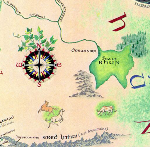
(Pauline Bayne's map)
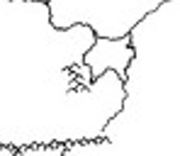
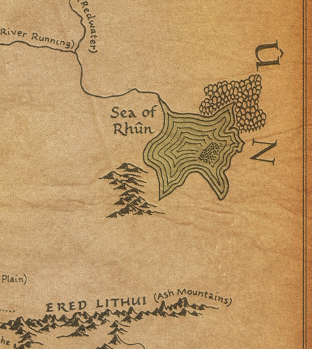 MERP Maps
(From the ICE module "Perils on the Sea of Rhûn"
(From the post-ICE "Inland Sea" supplement)
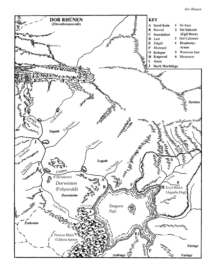
Lastly, the Big Map I've been basing my maps on, from the
Other Minds fanzine (Issue 1 and 2), includes the Eastern-most rivers, but not the others:
So, my question is, which of these do you think I should use for my Fourth Age campaign maps?
A. Strictly Tolkien-canon. Connect the sea of Rhûn only to the River Running and don't use any of the additionalrivers.
B. MERP ICE/fanon. The extra rivers add interesting features to lands that Tolkien didn't detail only because they weren't prominent in his writing.
C. OM compromise. Use the extra rivers that are farthest from the canon lands, but don't add the Othnen or the Uldona rivers.
Re: Poll: Additional rivers of Rhûn
Posted: Tue Nov 10, 2015 4:11 pm
by Falenthal
Option C. It adds more possibilities to the game, but without making rivers so frequent that they lack personality or importance.
Specially the southermost river could be explained as some kind of effect of the explosion of Mt. Doom and the fall of Barad-dûr, that might have shaken the Ered Lithui, cracked the surrounding lands, and therefore created a bank that could be filled by rainwater.
Re: Poll: Additional rivers of Rhûn
Posted: Tue Nov 10, 2015 4:20 pm
by Otaku-sempai
Well, there should certainly be other streams and small rivers feeding into the River Running, the Carnen and into (and out of) the Sea of Rhûn. However, I wouldn't expect all of them to show up on a map of the general area. I would include any waterways that seem like they would provide a significant impediment to travel, requiring finding a ford, bridge or ferry in order to cross them. Some of this depends on how much you agree with the topographical details added to the other maps. If they don't look right to you then don't include them.
Another question: Is the feature that Christopher Tolkien included on the Sea of Rhûn in the Unfinished Tales map supposed to be a large island? Or is it supposed to represent something else?
Re: Poll: Additional rivers of Rhûn
Posted: Tue Nov 10, 2015 9:15 pm
by Tolwen
michael.harrel wrote:I'm starting to integrate Rhûn and the lands of the Easterlings into my Fourth Age map, but running into a bit of a quandary involving the difference between the maps from "official" canon and the MERP/Post-MERP fanon. [...]
Lastly, the Big Map I've been basing my maps on, from the
Other Minds fanzine (Issue 1 and 2), includes the Eastern-most rivers, but not the others
So, my question is, which of these do you think I should use for my Fourth Age campaign maps?
A. Strictly Tolkien-canon. Connect the sea of Rhûn only to the River Running and don't use any of the additionalrivers.
B. MERP ICE/fanon. The extra rivers add interesting features to lands that Tolkien didn't detail only because they weren't prominent in his writing.
C. OM compromise. Use the extra rivers that are farthest from the canon lands, but don't add the Othnen or the Uldona rivers.
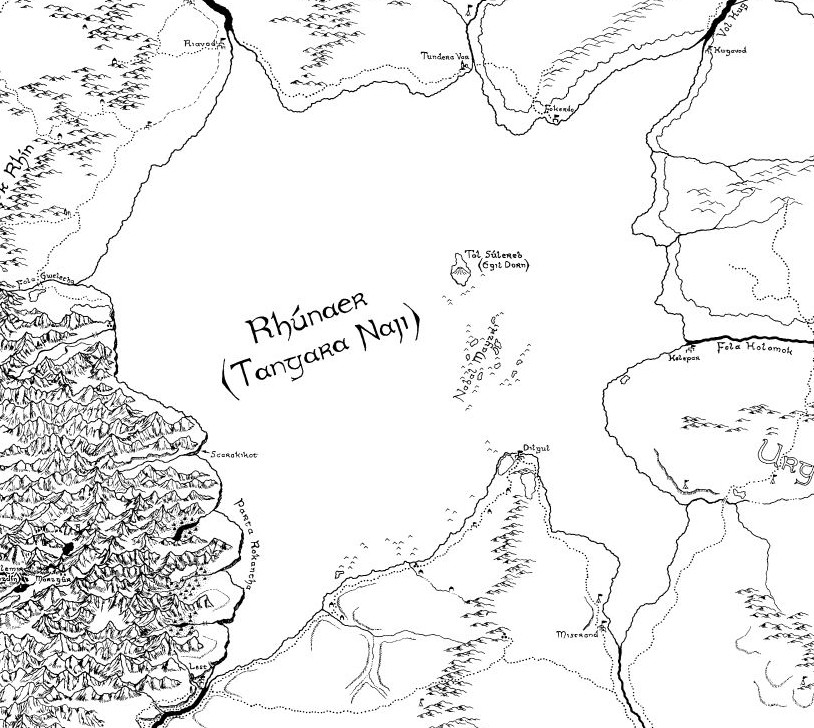
First of all, I'm pleased that you found the continental maps useful

Second, option and 2 and 3 (as a co-author of the maps I think I can state that) do not exclude each other. The continental maps were primarily that - to show key features of interest on this large scale. Smaller features in the Northwest were included for recognition purposes and because Tolkien had them on his maps. Otherwise some probably wouldn't been included. Smaller and secondary features in the uncharted lands were not included due to the vast amount that would have been necessary and because they were unnecessary for the project.
It is as in a real-world atlas: A world map lacks many features that those of smaller scale have (necessarily). If you draw such a smaller-scale map (i.e. zooming in), it must include more geographical features.
Similarly, IMO it goes without saying that there are a significant number of such secondary geographical features in the charted Northwest (especially in the peripheral areas like central and eastern Rhovanion) that are not included in the maps for various reasons.
EDIT: In conclusion, you shouldn't take the absence of features in the continental map as evidence that they aren't there. The choice of included features in the continental maps was largely governed by the need to display important or relevant features for the map's main purposes (giving an overview of the continent and making more clear the development over time) and not by cartographical accuracy in the sense of a comprehensive inclusion of features. Quite to the contrary, more detailed maps of smaller scale
should feature more features like rivers etc. Thus option 2 can be seen as a more detailed version of option 3 (but with some caveat due to the distorted nature of the MERP maps).
Cheers
Tolwen
Re: Poll: Additional rivers of Rhûn
Posted: Tue Nov 10, 2015 9:33 pm
by Tolwen
Otaku-sempai wrote:Another question: Is the feature that Christopher Tolkien included on the Sea of Rhûn in the Unfinished Tales map supposed to be a large island? Or is it supposed to represent something else?
AFAIK there is no official explanation for that. On the UT map (that doesn't include Umbar) it looks like an area of shoals (i.e. the dotted area), on my LotR map (that extends south to Umbar) it looks as it might be shoals around a few small islands. MERP followed the latter interpretation, but IIRC made the island larger than it appears on the LotR map.
Cheers
Tolwen
Re: Poll: Additional rivers of Rhûn
Posted: Wed Nov 11, 2015 1:18 pm
by Otaku-sempai
Tolwen wrote:AFAIK there is no official explanation for that. On the UT map (that doesn't include Umbar) it looks like an area of shoals (i.e. the dotted area), on my LotR map (that extends south to Umbar) it looks as it might be shoals around a few small islands. MERP followed the latter interpretation, but IIRC made the island larger than it appears on the LotR map.
Cheers
Tolwen
Okay. Thanks for the reply!